I’ve been rereading Hemingway’s Farewell to Arms which rekindled an interest in the history of WWI. The story’s debut is based on the author’s experience in the war as he drove an ambulance for the International Red Cross. After serious injury from mortar fire, he returned home unlike his lead character, Lt Frederic Henry.
While clicking around to find out more about the Italian campaign, I came across this excellent article in Vox: 40 maps that explain WW1. I find visuals so useful. There is far more information indicated by shadings, lines and labels within the four boundaries of a map than a writer can pound out on a keyboard . Although this passage sums up pretty well how devasting the war was.
One hundred years ago today, on August 4, 1914, German troops began pouring over the border into Belgium, starting the first major battle of World War I. The Great War killed 10 million people, redrew the map of Europe, and marked the rise of the United States as a global power. Here are 40 maps that explain the conflict — why it started, how the Allies won, and why the world has never been the same.
VOX
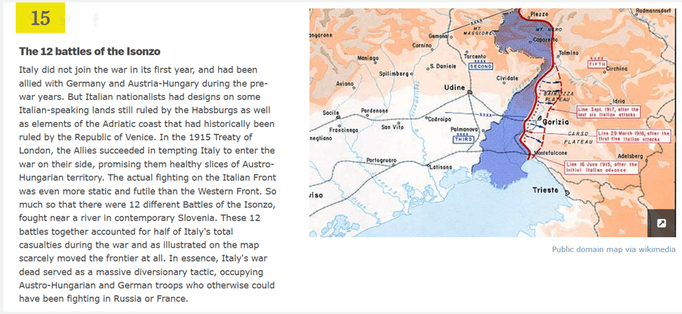
Hemingway cites enough geographic references to encourage the reader to look up exactly where his ambulance was called into service. Or, at least, I’m curious enough to look up Gorizio where he returns to base camp before he is sent on to Caporetto. In the passage about the retreat, as the Germans advance into Italy, Lt Henry’s goal is to reach Udine.
Further on in the book, Lt Henry and his sweet Catherine must flee to Switzerland in a row boat. The journey takes them along the coastline of the famous Lake Como. The porter who helps arrange their escape assures them the winds will be at their backs pushing them along the 35 kilometer journey.
Wartime stories have so much to offer. There’s conlict and suspense. There’s heartbreak. But most interestingly is the sudden change in circumstances creates a back lighting to social arrangements, making their properties just that much more apparent.
